This article may include affiliate links. If you click a link and make a purchase, Utah Outdoor Activities may receive a small commission at no extra cost to you. We only recommend products or services we personally use. FTC Affiliate Disclosure.
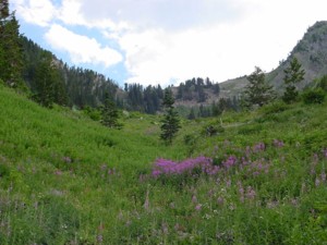
In the book Hiking the Wasatch; it states "One of the steepest trails in the Wasatch", and it's not lying. From the trail head, the trail goes straight up at a really steep grade to the first switchback. We required a 5 minute rest after the first hill because we were torn up by the sheer angle. We then moved on through the switch backs to the first meadow, which was surrounded by Aspen trees, Fire brush, and Indian Paint Brush wildflowers.
Looking up the next ridge gave us an indication of what we were up against. Steep once again to the ridge top. Once up there, the view started becoming more vivid, and the top of the basin is more exposed. We of course had the cameras out and were goofing off taking pictures. On the next ridge; we decided to stop and eat some lunch; Cliff Bars, String Cheese, Fruit Snacks, and Pistachios were in order to refuel because it was not over yet.
The basin is beautiful; preserved in its natural state, minus the hiking trail. Now it is onto the climb to the saddle and then to the top of Gobblers Knob. The first hill to the trail up the side of the basin is really steep, slick and drops off very far. Be careful on this part because a slip could lead to injury.
 Once at the top of this hill,you will see a trail heading straight up the side of the basin at an insane 60% grade for 1000 feet.
It is surely one of the steepest foot paths to a saddle I have ever seen. After the lug up the hill to the saddle we where provided a back to back view of Mill Creek, Big Cottonwood, and Little Cottonwood Canyons.
Once at the top of this hill,you will see a trail heading straight up the side of the basin at an insane 60% grade for 1000 feet.
It is surely one of the steepest foot paths to a saddle I have ever seen. After the lug up the hill to the saddle we where provided a back to back view of Mill Creek, Big Cottonwood, and Little Cottonwood Canyons.
We turned right and followed the path along the ridge to Gobblers Knob. Gobblers knob is 10,242 feet high, according to the USGS marker placed on the mountain top and is listed 28th of the top 32 highest peaks over 10,000 feet in Salt lake County. We turned right and followed the path along the ridge to Gobblers Knob. Gobblers knob is 10,242 feet high, according to the USGS marker placed on the mountain top and is listed 28th of the top 32 highest peaks over 10,000 feet in Salt lake County.
The views of the Salt Lake Valley to the west, the Tri-Canyons (Millcreek, Big & Little Cottonwood) were outstanding. It really felt like you could touch the clouds. Our decent was quick but harsh, with steep hills to get you down. This trail goes on the "More Difficult" list for sure. It really is a great place that I will visit again and You Should Too.
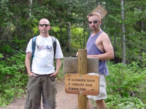
Trail Information and Directions
From the Mill Creek Canyon pay station the trail head is 7.8 miles.
Distance to Alexander Basin - 1 1/2 miles
Elevation Gain To Alexander Basin - 1640 vertical feet
Hiking Time - 2hrs 6 min - from trail head
Distance to Gobblers Knob - 2 1/4 miles
Elevation gain to Gobblers Knob - 3086 vertical feet to 10,242 feet
Hiking Time - 3hrs 14 min from trail head.
We hope you enjoyed this information. For more outdoor activities, please connect with us on YouTube, Facebook and Instagram. Help us keep this site up and running by visiting our online store which features outdoor themed gifts, decor and more. Thank you for visiting and for your ongoing support!