|
Canyonlands
National Park

View
from the Green River Overlook (NPS Photo by Neal Herbert)
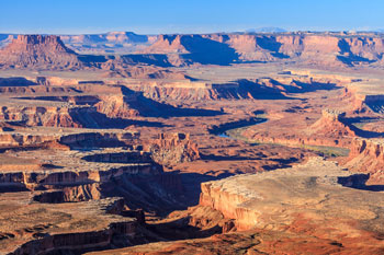
Canyonlands National Park preserves a
colorful landscape of sedimentary sandstones eroded into countless
canyons, mesas and buttes by the Colorado River and its tributaries.
Located in southeast Utah, the park sits in the heart of a vast basin
bordered by sheer cliffs of Wingate Sandstone.
The Colorado and Green rivers divide the
park into four districts: the Island in the Sky, the Needles, the Maze and
the rivers themselves. While the districts share a primitive desert
atmosphere, each retains its own character and offers different
opportunities for exploration and the study of natural and cultural
history.
Most visits to Canyonlands involve camping
along the trails, roads and rivers found here. The four districts are not
directly linked by any roads, so travel between them requires two to six
hours by car. Generally, people find it impractical to visit more than one
or two districts in a single trip.
History Of The Park
People have visited what
is now Canyonlands National Park for over 10,000 years. Over time, various
groups moved in and out of the area in concert with the availability of
natural resources and the technology for exploiting those resources.
Hunter-Gatherers
Humans first visited
Canyonlands over 10,000 years ago. Nomadic groups of hunter-gatherers
roamed throughout the southwest from 8,000 B.C. to 500 BC Living off the
land, these people depended on the availability of wild plants and animals
for their survival. They do not appear to have stayed in any one area for
very long. They left little in the way of artifacts and did not build
homes or other lasting structures. However, the hunter-gatherers during
this time created a great deal of intriguing rock art. Some of the best
examples of their art, known as “Barrier Canyon Style,” remain on the
cliff walls of Horseshoe Canyon.
Ancestral Puebloans & Fremont
Roughly two thousand years
ago, the hunter-gatherers began to rely more on domesticated animals and
plants for food. These early farmers are called the ancestral Puebloan
(formerly known as Anasazi) and Fremont people. They grew maize, beans and
squash, and kept dogs and turkeys. In order to tend their crops, they
lived year-round in villages like those preserved at Mesa Verde National
Park. Though the two groups overlapped, the Fremont lived mostly in
central Utah, while the ancestral Puebloans occupied the Four Corners
region. These cultures can be distinguished by their different tools,
pottery and rock art.
Over time, growing
populations at Mesa Verde caused a search for suitable land all over
southeast Utah’s canyon country. By A.D. 1200, large groups had moved
into the Needles District, especially in Salt Creek Canyon. However,
granaries and dwellings used by the ancestral Puebloans are scattered
throughout the park. Examples of these structures can be seen at Roadside
Ruin in the Needles, Aztec Butte on the Island in the Sky and along many
backcountry trails.
For many years, changing
weather patterns made growing crops more and more difficult. Around A.D.
1300, the ancestral Puebloans left the area and migrated south. Their
descendants include the people living in modern pueblos in New Mexico and
Arizona like Acoma, Zuni, and the Hopi Mesas.
Utes, Navajos and Paiutes
Before the ancestral
Puebloans left, other groups appeared in the area. The Ute and Paiute
cultures may have arrived as early as A.D. 800. The Navajo arrived from
the north sometime after A.D. 1300. All three groups still live here
today. These cultures initially lived more of a hunter-gatherer lifestyle
than the ancestral Puebloans. Their use and exploration of the Canyonlands
area appears to have been minimal.
European Exploration
For early European
explorers, Canyonlands offered more of an impediment to travel than a
destination. In the 1770s, the Spanish priests Escalante and Dominguez
circled the area, looking for a route between New Mexico and California.
Escalante and Dominguez failed, but trappers and traders from Taos and
Santa Fe succeeded. In the early 1800s, the “Old Spanish Trail” became
a well-worn route that passed through Moab like the highway does today.
The first Europeans to
explore Canyonlands were probably American and French trappers searching
western rivers for beaver and otter. Pelts from these animals were in
great demand in the east. One such trapper named Denis Julien carved his
name, the date and a picture of a boat along the Green River in 1836.
Julien also carved his name in Cataract Canyon and in Arches National
Park.
Official exploration of
the Colorado and Green rivers did not occur until 1869, when Major John
Wesley Powell led a group from Green River, Wyoming all the way through
the Grand Canyon in Arizona. During the three month expedition, Powell
mapped the rivers and recorded information about the natural and cultural
history of the area. One stop of his in what is now Canyonlands inspired
the following passage in his journal:
“…The landscape
everywhere, away from the river, is of rock – cliffs of rock; plateaus
of rock; terraces of rock; crags of rock – ten thousand strangely carved
forms.”
Powell repeated the trip a
few years later.
Settlement
European settlements in
southeast Utah developed from the missionary efforts of the Mormon Church.
In 1855, Mormons set up a mission in what is now Moab, but conflicts with
the Utes caused them to abandon it. The Hole in the Rock expedition–a
Mormon mission charged with settling southeast Utah–founded the town of
Bluff in 1880. The towns of Blanding, Moab and Monticello were settled
shortly thereafter. Most residents made their living as farmers,
prospectors or ranchers.
Ranching
From the 1880s to 1975,
local ranches used much of Canyonlands for winter pasture. Cowboys
searched the canyons for good feed and water. They constructed trails to
move their stock across the rugged terrain. To guard their herds, cowboys
lived in primitive camps for weeks at a time. The Cave Spring Trail in the
Needles District features one such camp.
Places throughout the park
bear the names of early cowboys. The Taylor, Holeman and Shafer families
grazed cattle and sheep in what is now the Island in the Sky. Don Cooper,
Mel Turner, D.L. Goudelock and Joe Titus ranched the Indian Creek area.
Their holdings under the Indian Creek Cattle Company were bought by the
Scorup and Sommerville families in 1914. Headquartered at the Dugout Ranch
outside the Needles District, the Indian Creek Cattle Company operates
today under ownership of the Nature Conservancy.
The
Biddlecome, Ekker,
Tidwell and Chaffin families wintered animals in the Maze. The Ekker Ranch
grazed cows on lands adjacent to the Maze until 2000. In addition to
cattle and sheep, the rugged country around the Maze harbored outlaws.
Robbers Roost, a mesa top west of the Maze, provided refuge for Robert
Leroy Parker (a.k.a. Butch Cassidy), Tom and Bill McCarty, Matt Warner and
others.
Mining
The growth of America’s
nuclear arms program in the 1950s created a high demand for uranium.
Geologists thought that Utah’s canyon country contained a significant
amount of uranium, but the rugged terrain made access difficult. To
encourage prospectors, the Atomic Energy Commission offered monetary
incentives and built almost 1,000 miles of road in southeast Utah. In
Canyonlands, these roads include the popular White Rim Road at the Island
in the Sky.
Though the region produced
substantial amounts of uranium, miners discovered very little in what is
now Canyonlands. However, the newly created roads led to other
discoveries. For the first time, much of Canyonlands could be seen from a
car. Tourism slowly increased as more people learned about the area’s
geologic wonders. By opening canyon county to travel, the miners blazed
the trail for the creation of a National Park.
Creating a Park
In the 1950s and early
1960s, Arches National Monument Superintendent Bates Wilson advocated the
creation of a National Park in what is now Canyonlands. Wilson led
government officials on jeep tours which featured lengthy talks over
campfires and hearty Dutch oven dinners. Secretary of the Interior Stewart
Udall joined one of these tours in 1961, and began lobbying for the
proposed park. On September 12, 1964, President Lyndon B. Johnson signed
Public Law 88-590 establishing Canyonlands National Park. Initially
consisting of 257,640 acres, Congress expanded Canyonlands to its present
size of 337,598 acres in 1971.
Activities in park include
auto touring, 4 wheel drive trails, hiking, camping, boating, horseback
riding and more.
Click
Here for information on campgrounds in the park.
Click
Here for more information on the Canyonlands National Park.
Click
Here for hotel reservations in Moab UT, just 26 miles from Canyon Lands
National Park.
|