This article may include affiliate links. If you click a link and make a purchase, Utah Outdoor Activities may receive a small commission at no extra cost to you. We only recommend products or services we personally use. FTC Affiliate Disclosure.
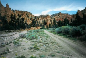
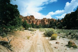
Beginning at the Casto Canyon trailhead the trail takes you into a wonderful world of red hoodoos, sandstone cliffs of white, pink and even green colors. The spectacular red rock is evident along most of the Casto canyon ride until you reach the forested areas of ponderosa pines where the colors changes with every turn of the trail. This trail includes several passages through the usually dry riverbed but local heavy thunderstorms can and will change that quickly.
The trail goes upwards easterly for approx 5.5 miles where it connects to the Sanford Road and the trail continues northeast approx., 1.9 miles and is referred to as the Barney Cove Trail. The trail junction with the Sanford road will also connect you to the Limeklin trail which drops back down towards the West and ends near the Panguitch Airport. The Sanford road additionally connects the rider to the Fremont ATV trail which the traveler can go south towards Tropic Reservoir and the Great Western Trail and north to the Piute ATV trail system. Elevation changes from Approx 7000 feet to 7840 at the Sanford Road/Barney Cove Trail area.
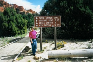
There are 2 ways to get to the trail head. From Panguitch head South along Hwy 89, (shoulder of the road only) towards the first dirt road on the left just prior to going up the hill. This dirt road takes you past the dump and continues along until you reach the trailhead. At the trail head there is a bathroom available.
The other approach is from Hwy 12 east towards Red Canyon, and just prior to reaching the first red rocks you will spot the sign for Losee and Casto Canyons on the left side (north) of the hwy. Take the good dirt road to the trailheads of Losee and then further on to Casto Canyon. Losee Canyon is not for OHV’s but just for bikes, hikers and horses. At the trailhead there is ample parking for trailers for both OHV’s and horses and includes a loading ramp, hitching rails and basic signs. There is no water at the trailhead and camping is not allowed at the parking area/trailhead.
More Information:
Dixie National Forest
1789 N Wedgewood Ln
Cedar City, UT 84721
Phone: (435)865-3700
Nearby City - Panguitch Utah
We hope you enjoyed this information. For more outdoor activities, please connect with us on YouTube, Facebook and Instagram. Help us keep this site up and running by visiting our online store which features outdoor themed gifts, decor and more. Thank you for visiting and for your ongoing support!