This article may include affiliate links. If you click a link and make a purchase, Utah Outdoor Activities may receive a small commission at no extra cost to you. We only recommend products or services we personally use. FTC Affiliate Disclosure.
When coming up to the Albion Basin, I had heard about a lake close to Devils Castle and the Sugarloaf called Cecret Lake, yes spelled with a C. I heard it was a short but nice hike, and since it was Utah Pioneer Day, I thought it would be a great way to spend the holiday, by going hiking. I started my day by finding out how many people actually chose to spend their 24th up the Albion Basin also.
I had to park at the Sunnyside lot because the Cecret Lake lot was full. So I had a good ½ mile warm up on the legs to get the blood flowing. Arriving at the trail head; it starts at the west side of the camp ground; which I followed for a short distance to a service road, then back to a foot trail again. Along the way, there are interpretive signs to tell you about the basin, its plants and animals, and its geological history. The trail to the lake is a pretty steady grade all the way, except for the last little bit to the lake which has hardly any grade at all.
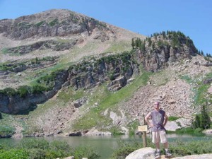
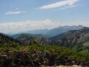
Cecret Lake sits at 9, 220 feet above sea level. It is a really nice lake, with red rock and boulder fields surrounding it in the Sugarloaf circ. There is very little cover so bring your sunscreen. I wandered around the lake for a little while, encircling the entire lake. Then I decided to go up to the pass, just to see what the views were like. It was quite a hoof to the first ridge top. Then up the Sugarloaf ski run, then across the meadow to a saddle clearly visible ahead. You can always follow the road up to the pass as well. But I being the adventure driven person I decided to do the foot trail to the pass. Wow, I could see the east side of American Fork Twins, Mt Baldy to the right, and the Sugarloaf to the left. American Fork Canyon and Mt Timpanogos are also visible from this Saddle.
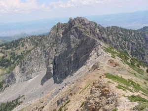
So here I go on to the top of the Sugarloaf. The beginning of this mountain is very steep, and loose trail scrawl from erosion make it very slick. Then just when you think you are having fun, the trail ends at a quarry of loose rock you have to scramble over to get all the way to the top. The Sugarloaf is 11, 051 feet high. The views of Mt Superior and Devils Castle are unreal. This was my first solo Peak Bag, and it was a riot. I descended to the Saddle between Devils Castle and the Sugarloaf and made my way down the face of the mountain to return to the Cecret Lake Trail. These mountains offer a variety of places to go and things to see, that you will never see anywhere else. That is why my friends call us the Wish You Were Here Boys. Yes we do wish you were!
Trail Information:
Little Cottonwood Canyon- Trail Head- Albion Basin Campground- Alta
Distance to Cecret Lake- ¾ mile
Elevation Gain- 420 vertical feet to 9220 feet
Hiking Time- 33 min
Distance to Sugarloaf Pass- 1 ¾ miles
Elevation Gain- 1100 feet to 10, 550 feet
Hiking Time- 2hrs 30min
Distance to Sugarloaf Peak- 2.25 miles
Elevation Gain- 1651 feet to 11,051 feet
Hiking Time- 3 hrs 1 min
We hope you enjoyed this information. For more outdoor activities, please connect with us on YouTube, Facebook and Instagram. Help us keep this site up and running by visiting our online store which features outdoor themed gifts, decor and more. Thank you for visiting and for your ongoing support!