This article may include affiliate links. If you click a link and make a purchase, Utah Outdoor Activities may receive a small commission at no extra cost to you. We only recommend products or services we personally use. FTC Affiliate Disclosure.
The turn off to Clay Canyon is located 1.5 miles from the town of Fairfield Utah. This Canyon is well known as being the location mined for Variscite. This yellow and green mineral were mined for the jewelry trade, which continued up until about World War I. Now days the mineral is collected by rock hound enthusiasts for personal use only. If you plan on collecting this mineral, you had better do some homework before hand. It takes a very trained eye to spot the rock the mineral is located in and in most cases the rock will have to be cut open to expose the Variscite.
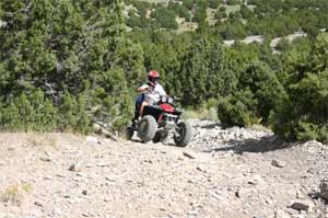
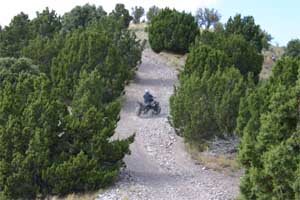
Our trip to Clay Canyon was solely for the purpose of riding our ATV's. As you travel up Clay Canyon the right hand side of the road is closed due to the cleanup of Manning Canyon, everything to the left is open to OHV travel. You will find several trails/roads leading in every direction. Most of the trails we traveled required some riding skills, most were very rocky and steep. On our adventure we found ourselves riding on the ridge line that separates Clay Canyon from Sunshine Canyon. If you are not an experienced rider and you find yourself on this trail turn around, this trail is very steep and very rocky!
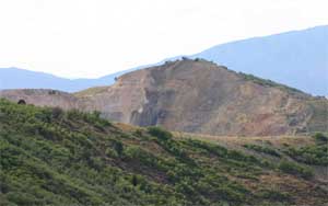
 If you are an experienced rider and want a sense of adventure give this trail a try. Once you reach the top you will be offered a small treat, a view into the Mercur Gold Mine. The start of this ridge line trail is located at the end of Clay Canyon road, next too a large pit that is being used as a OHV play area.
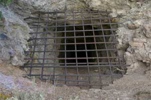
There are plenty of riding opportunities in this area with the lower trails being more user friendly. This area offers trails for all riders. This trail system offers well graded dirt roads, narrow trails leading through washes, and steep rocky, rutted scary trails. You may even link from this trail system to the Five Mile Pass OHV area. Use caution when riding in this area as you are bound to run into covered mine shafts, and obvious areas where mining has taken place.
Driving Directions:
Travel on State Route 73 from Lehi, Utah to Fairfield Utah. The turn off to Clay Canyon is located 1.5 miles from Fairfield. This road is well graded and heads north through dry farms. As you travel down this road it will make a 90 degree turn and head west. Shortly after this turn you will see a large BLM sign that has a map posted of this area. From this sign travel to your right towards Manning Canyon, you will see the signs for the closed area. Stay to the left and it will lead you to Clay Canyon. Find an area on the left hand side of the road to stage and make your own adventure on the many trails this area has to offer.
More Information:
BLM Salt Lake Field Office
2370 South 2300 West
Salt Lake City, UT 84119
Phone: (801) 977-4300
We hope you enjoyed this information. For more outdoor activities, please connect with us on YouTube, Facebook and Instagram. Help us keep this site up and running by visiting our online store which features outdoor themed gifts, decor and more. Thank you for visiting and for your ongoing support!