This article may include affiliate links. If you click a link and make a purchase, Utah Outdoor Activities may receive a small commission at no extra cost to you. We only recommend products or services we personally use. FTC Affiliate Disclosure.
In September of 1996, President Clinton designated this huge national monument, which at 1.9 million acres dominates any map of Southern Utah. The monument is a geologic sampler, with a huge variety of formations, features, and world-class paleontological sites.
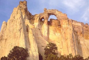
The Grand Staircase is a geological formation spanning eons of time and is a territory of multicolored cliffs, plateaus, mesas, buttes, pinnacles, and canyons. It is divided into three distinct sections: the Grand Staircase, the Kaiparowits Plateau, and the Canyons of the Escalante.
Despite their different topographies, these three sections share certain qualities: great distances, enormously difficult terrain, and a remoteness rarely equaled in the lower forty-eight states. Human endeavors have always been limited on these lands, yet their very remoteness and isolation have attracted seekers of adventure or solitude and those who hope to understand the natural world through the Monument's wealth of scientific information.
The highest part of the Monument is the Kaiparowits Plateau. From the air, the Plateau appears to fan out southward from the town of Escalante into an enormous grayish green scalene triangle, ending far to the south at Lake Powell and the Paria Plateau. The 800,000-plus acres of the Kaiparowits form the wildest, most arid, and most remote part of the Monument.
The fossil-rich rocks of the Kaiparowits contain perhaps "the best and most continuous record of Late Cretaceous terrestrial life in the world." The plateau has been described as a "stony, desiccated maze of canyons," with few isolated springs and a handful of creeks. It is a land of broad canyons, sheer cliffs, red hills of oxidized rock created by underground coal fires, and soils poisonous to most plants. But it is also a land of forested, level benches, thousand-year-old junipers, and a rich variety of mammals and birds, including seventeen species of raptors that ride the ever-present winds.
The 42-mile-long Straight Cliffs mark the eastern edge of the plateau, ending at Fiftymile Mountain in the southeast. Nowhere else in this remarkable monument do the words wind, space, solitude, silence, and distance have as much meaning as here.
To the north of Fiftymile Bench is the Aquarius Plateau, dominated by the 11,000-foot Boulder Mountain. To the east lies an expanse of pale Navajo sandstone which the Escalante River and its tributaries, flowing down from the plateau, have carved into a maze of canyons. In this arid territory, it is ironically water that has done the most to shape the landscape.
But this land of rock surprises: deep in the canyons along sun-dappled streams, lush riparian worlds flourish. Cottonwoods, box elder, willows, Gambel's oak, and the introduced tamarisk form often impenetrable thickets. Shaded alcoves and undercut rock faces reveal hanging gardens, nourished by dripping seeps.
Entry into the national monument is by two paved roads: Highway 89 from the Kanab/Big Water area and Highway 12 from Escalante/Boulder area. All other roads are fairly primitive and remote.
More Information:
Grand Staircase-Escalante National Monument
Kanab Headquarters
669 South Highway 89A
Kanab, Utah 84741
Nearby Lodging:
Kanab Utah Hotels (Affiliate Link)
We hope you enjoyed this information. For more outdoor activities, please connect with us on YouTube, Facebook and Instagram. Help us keep this site up and running by visiting our online store which features outdoor themed gifts, decor and more. Thank you for visiting and for your ongoing support!