Essentials For Exploring Arches National Park: Each year, park rangers respond to dozens of search of rescue incidents in the park, many of which involve heat exhaustion and/or dehydration or improper footwear. Always carry (and drink) water! Even the shortest stroll will make you thirsty on a 100 degree day. One gallon per person per day is recommended for longer hikes. Water available only at the visitor center and at Devils Garden Campground.
Wear sturdy shoes with enough tread to give you good traction. Do not hike in leather-soled shoes or boots. Some trails cover uneven terrain and follow rock ledges. Protect your skin with a hat, long-sleeved shirt, and sunscreen! There is little in the desert. The sun is intense year round and can easily burn your skin, especially in the summer.
Hiking Trails Available In Arches National Park
Desert Nature Trail
Start: Arches Visitor Center
Length: 0.2 mile round trip
Time: 15 to 30 minutes
Discover the adaptations of plants and animals in the desert on a self-guided nature walk. Tail guide available at the trail head.
Balanced Rock
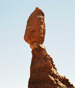
Start: Balanced Rock parking area
Length: 0.3 mile round trip
Time: 15 to 30 minutes
A loop trail at the base of a fragile, picturesque rock formation.
The Windows (Click here for full article)
Start: Windows parking area
Length: 1 mile round trip
Time: 30 to 60 minutes
A gentle climb up a gravel lop trail leads to three massive arches (North and South Windows and Turret Arch). An alternate return, slightly longer, is by way of the primitive loop around the back of the two Windows. The primitive loop trail starts at the South Window viewpoint.
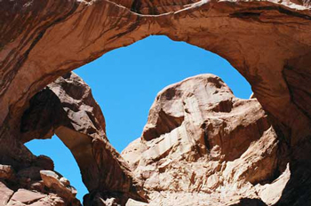
Double Arch (Click here for full article)
Start: Double Arch parking area
Length: 0.5 mile round trip
Time: 15 to 30 minutes
A relatively flat, sandy trail leads to the base of two giant arch spans which are joined at one end.
Delicate Arch Viewpoint
Start: Delicate Arch viewpoint parking area
Length: 100 yards round trip
Time: 10 to 15 minutes
In addition to the short accessible trail, another (moderately strenuous) hiking trail climbs 0.5 mile toward Delicate Arch and ends at the rim of a steep canyon that separates the viewpoint from the arch. (This is not the popular trail to Delicate Arch, which starts at the Wolfe Ranch parking area.)
Sand Dune Arch (Click here for full article)
Start: Sand Dune Arch parking area
Length: 0.4 mile round trip
Time: 15 to 30 minutes
Trail leads through deep sand to a secluded arch among sandstone fins. DO NOT CLIMB OR JUMP OFF THE ARCH.
Broken Arch(Click here for full article)
Start: Sand Dune Arch parking area or Devils Garden campground across from campsite #40
Length: 1.2 miles round trip; 2 miles including the loop
Time: 30 to 60 minutes
From the Sand Dune Arch parking area, the trail cuts across a large meadow to the arch and continues to the campground. Loop trail leads through fin canyons with sand dunes and slickrock.
Skyline Arch
Start: Skyline Arch parking area
Length: 0.4 mile round trip
Time: 10 to 20 minutes
A short hike on a flat, well-defined trail. On a cold November night in 1940, a large chunk fell out of the arch, instantly doubling the size of its opening.
Landscape Arch (Click here for full article)
Start: The Devils Garden trailhead parking area
Length: 2 miles round trip
Time: 30 to 60 minutes
A relatively flat, gravel-surfaced trail (usually heavily populated with hikers) leads to a spectacular ribbon of rock, whose span is more than a football field in length. Short side trips to Tunnel and Pine Tree Arches. Trail guide available at trailhead.
Park Avenue
Start: Park Avenue parking area
End: Courthouse Towers parking area
Length: 1 mile one way
Time: 30 to 60 minutes
Elevation Change: 320 feet
From Park Avenue parking area, the trail descends steeply into a spectacular canyon and continues down the wash to Courthouse Towers. If you have a shuttle driver, you can begin at one point and be picked up at the other. For round -trip hiking, re-trace your step along the trail rather than walk along the park road.
Tower Arch
Start: Klondike Bluffs parking area, via the Salt Valley Road
Length: 3.4 miles round trip
Time: 2 to 3 hours
The trail climbs a steep, but short, rock wall, cuts across a valley and then meanders through sandstone fins and sand dunes. An alternate, shorter trail (0.3 miles one way), begins at the west side of Tower Arch. This unpaved road washes out quickly in rainstorms; inquire at the visitors center about the road conditions before heading out.
Delicate Arch (Click here for full article)
Start: Wolfe Ranch parking area
Length: 3 mile round trip
Time: 2 to 3 hours
Elevation Change: 480 feet
Take at least a quart of water per person! There is no shade. Open slickrock with some exposure to heights. The first half-mile is a wide, well-defined trail. Upon reaching the slickrock, follow the rock cairns. The trail climbs gradually and levels out toward the top of the rock face. Just before you get to Delicate Arch, the trail goes along a rock ledge for about 200 yards.
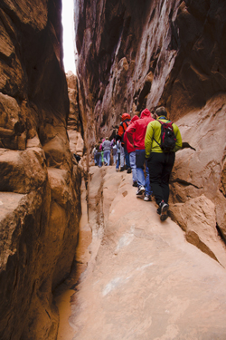
Fiery Furnace (Fee Area)
Any visitor entering the Fiery Furnace must obtain a ticket for a ranger-guided hike or a hiking permit at the visitors center.
Guided hikes are offered daily (April Through October) through this trail-less area. Reservations are required and tickets must be purchased in person at the visitors center (up to seven days in advance). These popular hikes may fill one to two days in advance. Group size is ten people. If there are more than ten in your group, you may request a special walk. It is recommended that such requests be made four weeks in advance. The Fiery Furnace is a maze like labyrinth of narrow sandstone canyons. These 2 to 3 hour hikes wind through terrain that occasionally requires the use of hands and feet to scramble up through narrow cracks and along narrow ledges above drop-offs.
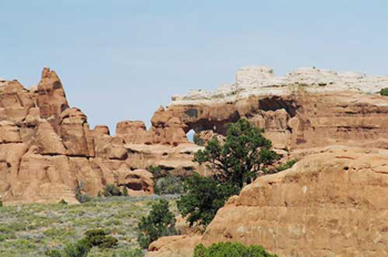
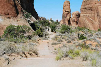
Devils Garden (including primitive loop trail) (Click here for full article)
Start: Devils Garden Trailhead parking area
Length: 7.2 miles round trip, including all spur trails to points of interest
Time: 3 to 5 hours
Longest of the maintained trails in the parks, Devils Garden Trail leads to eight awe-inspiring arches. Expect narrow ledges with rocky surface hiking and scrambling on slickrock. Not recommended when rock is wet or snowy. Trail guide available at trailhead.
Double O Arch (Click here for full article)
Start: Devils Garden Trailhead parking area
Length: 4 miles
Time: 2 to 3 hours
Elevation Change: 480 feet
Beyond Landscape Arch, the trail becomes more challenging as it climbs over sandstone slabs; footing is rocky; there are narrow ledges with exposures to heights. Spur trails lead to Partition and Navajo Arches Dark Angel is one-half mile farther. Trail guide available at trailhead.
Tapestry Arch Trail (Click here for full article)
Distance to Tapestry Arch- 1 mile
Elevation Gain- 250 feet
Hiking Time- 45 min to the top of Tapestry Arch
Nearby Lodging / Campgrounds:
Moab Utah Campgrounds and Primitive Camping Areas
Moab Utah Hotels (Affiliate Link)
More Information:
Arches National Park
PO Box 907
Moab, UT 84532
We hope you enjoyed this information. For more outdoor activities, please connect with us on YouTube, Facebook and Instagram. Help us keep this site up and running by visiting our online store which features outdoor themed gifts, decor and more. Thank you for visiting and for your ongoing support!