This article may include affiliate links. If you click a link and make a purchase, Utah Outdoor Activities may receive a small commission at no extra cost to you. We only recommend products or services we personally use. FTC Affiliate Disclosure.
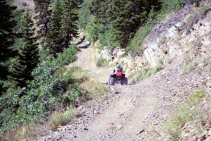
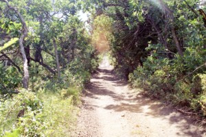
Trail 295 begins approx 3.0 miles up the Mineral Basin road. The trail starts right off with a little challenging rock outcrop. As soon as you get passed that the trail levels out, and you start making your way through groves of quaken aspens.
About a quarter of a mile up the trail you will come to a sign that marks Grave Yard Flat. The trail also forks at this point. You can continue up the mountain, or take the other fork that takes you down a steep rocky trail back to the Mineral Basin main road. We stayed on 295 which headed up the mountain. You will quickly come to several fairly steep and rocky switch backs, which will take you out along a beautiful sloop. The entire trail was approximately 3 to 4 miles. It was a fairly good grade the entire route, with a lot of lose rocks on the trail.
As you continued up the trail you started heading into the thick large pines. When you look up to the skyline, and think you are almost to the top of the mountain, the trail ends suddenly. At the end of the trail you can see a fork. One fork goes up and the trail ends in the trees. The lower fork drops down a sever slop and ends. It looked as if we could take the lower fork and swing back to the main trail. However after trial and error (almost rolling) we don't recommend taking either fork. There is a fairly level place and the end of the trail where you can stop a have lunch or a snack.
Directions:
From I-15 take the Alpine exit heading east. This road will take you to American Fork Canyon. Once your heading up the canyon you will come to the Tibble Fork junction. Once at Tibble Fork you will see a large staging area. From the staging area head up the Mineral Basin road. Approx 3.0 miles up the road you will come to the trail head. The trail head is marked with the trail number on a forest service sign.
More Information:
Uinta-Wasatch-Cache National Forest
Provo Office
88 West 100 North
Provo, UT 84601
Phone: (801) 342-5100
We hope you enjoyed this information. For more outdoor activities, please connect with us on YouTube, Facebook and Instagram. Help us keep this site up and running by visiting our online store which features outdoor themed gifts, decor and more. Thank you for visiting and for your ongoing support!