This article may include affiliate links. If you click a link and make a purchase, Utah Outdoor Activities may receive a small commission at no extra cost to you. We only recommend products or services we personally use. FTC Affiliate Disclosure.
The Mineral Fork Trail is the last ATV trail up Big Cottonwood Canyon. This trail is projected to be closed, so before you ride this trail check with the Wasatch - Cache National Forest Service to be sure the trail is still open.
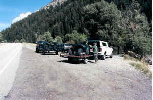
The trail head is approx 6.5 miles up Big Cottonwood Canyon. The parking area just appears to be a large pull out on the side of the canyon road. How you know your in the right area is to look for a large metal gate on what appears to be a private road. As you can see by the picture above, there is not much room for parking. If you arrive at this trail and see several trucks with trailers, you may want to ride this trail another day.
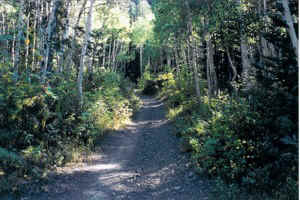
At the beginning of the trail you will start a slow but steady climb up the mountain. The trail switches back several times and you will cross a small creek that cascades down two beautiful water falls. You will also encounter the toughest part of the trail.
 Two large boulders that have fallen off the side of the mountain making for one tight tricky squeeze. As you continue up the trail you will still have a fairly steady climb through aspen and pine groves. This part of the trail is the upper Mineral Fork Valley.
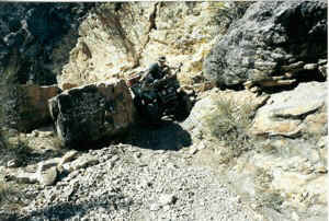
The most significant land mark on this trail is the Wasatch Mine. You will see the mine tailings as you make your way through the valley. The mine also marks the end of the trail. The mine entrance has a large metal grate to keep people out, for a good reason, as this mine is known to have bad air and is very polluted.
There is a small stream that runs out of the mine and the water has a light orange tint to it, so I would highly recommend not drinking the water.
The views on this trail are fantastic, we saw several Deer and Mountain Goats.
If you have not ridden this trail before, I would recommend you do.
Directions:
The trail head is approx 6.5 miles from the mouth of Big Cottonwood Canyon. When you pass the S turn you will have approx 1.5 miles. Look for a large pullout on the right side of the canyon road. Also look for a large metal gate that appears to be on a private road.
Trail Information:
Location: Big Cottonwood Canyon
Uinta-Wasatch-Cache National Forest
Salt Lake Office
Phone: (801) 236-3400
125 South State Street
Salt Lake City, UT 84138
We hope you enjoyed this information. For more outdoor activities, please connect with us on YouTube, Facebook and Instagram. Help us keep this site up and running by visiting our online store which features outdoor themed gifts, decor and more. Thank you for visiting and for your ongoing support!