This article may include affiliate links. If you click a link and make a purchase, Utah Outdoor Activities may receive a small commission at no extra cost to you. We only recommend products or services we personally use. FTC Affiliate Disclosure.
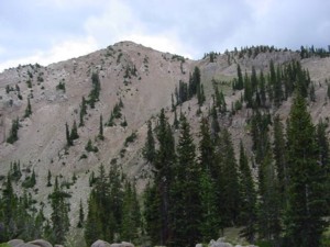
Catherine Pass was a place I had already been to, but climbing Sunset Peak was something I had not done. This peak is clearly visible from Catherine Pass. I started at the Catherine Pass trail head and went to the Pass. Once on the Pass, we headed up the sandy incline to Sunset Pass. From here there is a minor saddle with a well traveled foot path to the summit.
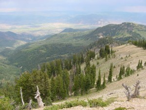
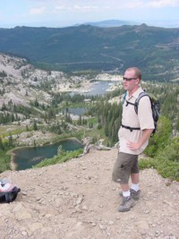
This trail to the summit is steep, but short and does not take very long. Up a couple of switchbacks and you are at the top. It has the best view of the Brighton Lakes area. Also views of Heber, Mt Timpanogos, as well as the Uintas. Being the explorer that I am, getting up there was a treat in its self. We ate lunch, then while taking some pictures I saw lightning, heard some thunder, and knew it was time to get off the ridge tops. So making a fast bolt off the summit, down to the minor saddle, I traversed the front side of Sunset Peak to Lake Catherine. At Lake Catherine I ran into some friends who had come up the Brighton Lakes Trail. Being at this lake is superb. It is quiet, serene, and just damn cozy to say the least.
They were on the pass and got down to the lake to be off the ridge tops too. They watched me traverse the front side of Sunset Peak down to the lake and said it looked sweet. We all took some time hanging out by the lake, then the rain started to fall so we all made for Catherine Pass, up the steep trail to the saddle. Warning: Lightning is a leading cause of outdoor fatalities in the State of Utah. If you see black clouds, then they are surely thunderheads. Be aware at all times the weather, if you hear thunder and it sounds close, it is a safe bet and it would be a good idea to get off the ridge tops. Thunderheads charge as they climb over our mountains, making lighting on a peak or a ridge that much more lethal.
Besides, usually if you are on a peak, you are above the timberline, making you the highest point of contact. Best not to take your chance with nature’s ultimate light show. Pretty as a lightning storm can be, deadly are the consequences if you are in the wrong place at the wrong time. So pay attention to the skies. It is really easy to get lost in the beauty of the landscape, and not pay attention to the weather. The best is to call the National Weather Service for up to date forecasting before you go hike, or check them out online. Pick a clear day for peak bag hikes, clear and sunny days are less likely to develop thunderheads than a partly or mostly cloudy day. All in all, Sunset Peak was a great hike, if you get a chance you should visit there, the views are awesome, and you get to experience climbing a mountain first hand.
Trail Information:
Little Cottonwood Canyon- Trail Head-Sunnyside lot, Albion Basin, Alta
Distance to Catherine Pass- 1.5miles
Elevation Change- 1200 vertical feet to10, 220 feet
Hiking Time- 1hr
Distance to Sunset Peak- 2.25miles
Elevation Change- 1658 vertical feet to 10,529 feet
Hiking Time- 1hr 40min
We hope you enjoyed this information. For more outdoor activities, please connect with us on YouTube, Facebook and Instagram. Help us keep this site up and running by visiting our online store which features outdoor themed gifts, decor and more. Thank you for visiting and for your ongoing support!