This article may include affiliate links. If you click a link and make a purchase, Utah Outdoor Activities may receive a small commission at no extra cost to you. We only recommend products or services we personally use. FTC Affiliate Disclosure.
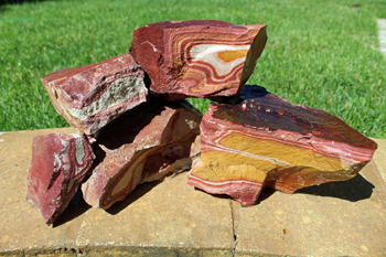
A striking feature of Vernon Hills wonderstone is its intricately folded bands that create colorful designs in cream, yellow-brown, and multiple shades of maroon.
Geologic information:
The Vernon Hills wonderstone is a welded-vitric tuff (vitric means glassy) of rhyolitic composition. It is a volcanic rock composed predominantly of volcanic glass particles which have been welded or stuck together by heat and compacted by the weight of overlying material. Alteration of the rock by circulating ground water produced the colorful banding. The maroon and yellow-brown colors are due to the presence of iron oxides.
How to get there:
From the southern edge of Tooele, travel south on State Highway 36 about 31 miles to the town of Vernon. Continue on highway 36 an additional 4 1/2 miles until you reach a dirt road adjacent to and west of the railroad tracks. Turn north (left) onto the dirt road and travel next to the railroad tracks for 1.7 miles until the road curves to the northwest. From the curve, travel 0.4 miles to the end of the road.
Where to collect:
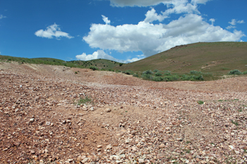
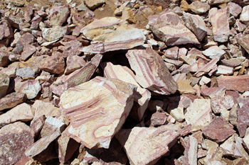
Piles of wonderstone are located near the end of the road. A private mining claim is in this area so do not collect on any marked claims or rock piles showing signs of recent mining activity.
Useful maps:
Utah highway map, Rush Valley 1:100,000-scale topographic map, and Lofgreen 7.5-minute topographic map. Topographic maps can be obtained from the Natural Resources Map & Bookstore, 1594 North Temple, Salt Lake City, UT 84114-6100, (801) 537-3320 or 1-888-UTAH MAP.
Land ownership:
Private mining claim and Bureau of Land Management (BLM) public lands.
Precautions, miscellaneous:
A four-wheel-drive vehicle is recommended but not required for the last 2 miles of the journey. Do not collect on any marked claims or rock piles showing signs of recent mining activity. Bring a rock hammer and protective eyewear if you intend to break pieces of rock. A hat and water are recommended. Please carry out your trash. Have fun collecting!
More Information:
Utah Bureau of Land Management
Utah State Office
440 West 200 South, Suite 500
Salt Lake City, Utah 84145-0155
Phone: (801) 539-4001
Nearby Cities / Towns - Eureka Utah
We hope you enjoyed this information. For more outdoor activities, please connect with us on YouTube, Facebook and Instagram. Help us keep this site up and running by visiting our online store which features outdoor themed gifts, decor and more. Thank you for visiting and for your ongoing support!