Limber Pine Nature Trail - Logan Canyon Utah
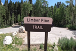 The Limber Pine Trail, is a family friendly trail located at the top of Logan Canyon, just before you drop into Garden City, Utah. This 1.2-mile loop will lead you through thick groves of pine trees, aspens and provides beautiful views of the surrounding area. One of the trail highlights is the cluster of Limber Pines in which this trail got its name. This cluster of pine trees is thought to be around 560 years old, and are said to have been planted by the Clark's Nutcracker.
Hiking the Mirror Lake Shoreline Trail
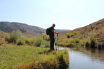
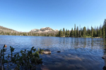 This trail, according to the sign, is a 2.1-mile loop around the entire lake. The shoreline trail begins just past the restrooms and you can hike in either direction around the lake. While hiking, you will experience beautiful views of the lake, and the mountain peaks in the distance. The trail is relatively flat, with several board walks crossing the marshy areas. Not only does this trail provide spectacular views of this natural lake, it’s also a great way to access different fishing locations around the lake.
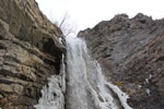
Double Falls Payson Canyon
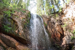 The trailhead to Double Falls is located approximately 9.8 miles from the mouth of Payson Canyon. The parking area is located on the south side of the canyon road. There is a wood sign in the parking lot marked Jones Ranch with a forest service map. The actual trail to Double Falls is not marked, and the only way I located the trail, was using google maps. From the parking lot you will see a road heading east/northeast. This road ends at a large primitive camping area. On the east/northeast side of this primitive camping area, you will see a trail heading into the aspens.
Paul Bunyan’s Woodpile
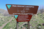 The Paul Bunyan’s Wood Pile is a natural geological formation that formed about 30 million years ago, when a lava flow cooled and created what looks like lava logs. These lava logs are about a foot in diameter with some measuring up to 15 feet in length. The logs are neatly stacked like a massive wood pile.
Hiking the Temple Fork Sawmill Trail
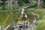
 The Temple Fork Trail located in Logan Canyon is an easy, beautiful, family friendly hike that can be enjoyed by all ages. The trail follows the Temple Fork Creek, and ends at an old historical sawmill that was constructed in 1877. From the parking area, the trail meanders through a fairly flat sage brush valley and offers views of the creek and several beaver ponds.
Wind Cave Hiking Trail Logan Utah
 Known as one of the most popular trails in Logan Canyon, the Wind Cave Hiking trail is located approximately 5.3 miles up the canyon across from the Guinavah Campground. This family friendly hike offers beautiful views with the highlight of the trail being the natural cave. The Wind Cave trail is considered a moderate hike, but because of the large switch backs the constant elevation gain of 1030 feet is more gradual than straight up. As you hike the trail, views of the surrounding canyon are spectacular and there are several areas to stop, rest, and take in the scenery. One view from the Wind Cave trail that will instantly stand out is the 200 foot cliffs located across the canyon known as China Wall.
Ferguson Canyon Trail to the Overlook
 Recently Utah Outdoor Activities received an email from one of our visitors asking us why the Ferguson Canyon Trail was not listed on our website. The answer to this question is because we have never hiked this trail before. So, we made it a point to get out and hike this trail, and in this article we will share our experience with you. Although, this trail is rated as “hard”, it all depends on how far you choose to hike. There are several points of interest that could be considered a great place to end your hike and return to the trail head.
Alpine Pond Trail Cedar Breaks
 Hiking in the Cedar Breaks National Monument is one way to enjoy the uniqueness of this park. Most of the hikes in the monument provide views of the 3-mile wide amphitheater. The Alpine Pond Trail is a 2.2-mile loop that makes its way through meadows, aspens, pines, and connects with two different parking areas. You can begin this hike at the Chesman Ridge Overlook or the winter warming yurt parking area. Once you begin this hike you will have the option to hike the lower loop or the upper loop.
Winter Hike to Battle Creek Falls
 The hike to Battle Creek Falls is a kid and dog friendly hike the whole family will enjoy. The trail begins east of the Kiwanis Park and starts out as a large service road with little elevation gain. The trail meanders its way up Battle Creek Canyon, which was named after an Indian battle with settlers during the winter of 1848-1849. Depending on the time of year the lower portion of Battle Creek will be dry as a bone, confusing first time visitors of the possibility of an actual flowing waterfall. If you continue up the trail, you will soon discover a water catch basin that catches the creek and pipes it to the large tanks below, which explains the dry creek.
Lower Calf Creek Falls
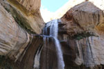 Few places on this planet can compare to the pristine beauty that defines Lower Calf Creek Falls. When you picture a desert oasis, this is the place that springs to mind. It is a majestic waterfall that will steal your breath away. Clear water plunges approximately 126 feet from sandstone cliffs into a deep pool below. The pool nestled at the base of the falls becomes a perfect swimming hole for a hot summer day. Algae growing on sandstone cliffs, underneath the spray of the falls, add brilliant splashes of color to the entire cove.
Hike to Long Lake - Utah's Uinta Mountains
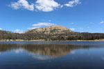 Utah’s Uinta Mountains are well known for pristine mountain lakes, towering peaks, and gorgeous scenery. Visitors can enjoy many outdoor activities such as camping, sightseeing, photography, fishing, and of course hiking. In this outdoor adventure we’re taking a day hike to Long Lake. The trailhead to Long Lake is actually the starting point to many high mountain lakes. Hikers will enjoy views of Crystal Lake, many different ponds, and stream crossings while hiking to Long Lake. For those who are a little more adventurous and have enough “TIME”, there are many different junctions off the main trail.
Adams Canyon Waterfall Trail
 The Adams Canyon Trail is one of the most beautiful, scenic trails we have experienced in some time. This trail is the second most popular trail in Davis County and for good reasons: accessibility, beautiful scenery, shade, water, and the reward of the 40-foot Adams Waterfall for those who push on to the top. From the parking lot, the trail winds its way through several switchbacks while climbing the first 500 feet in elevation. The trail is covered in soft sand, requiring a little more effort to crest the first hill. But don’t let this discourage you from pushing on, as once you crest the hill, the trail levels out to provide the first views of the valley below.
The Frary Peak Trail - Antelope Island
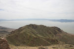 Antelope Island; famous for its Bison herd of around 700 animals, the Fielding Garr Ranch; the first permanent residence on the island, and the Great Salt Lake; the largest natural lake west of the Mississippi River. While many visitors enjoy the island from the road, rest areas, and the beaches; those that explore off road and hike one of the many trails get to discover the inner beauty of the island. The Frary Peak Trail is just one of the many trails available on the island. This trail takes you on a 3.08 mile journey providing spectacular views, and up close scenery you can only enjoy on foot.
The Red Reef Hiking Trail
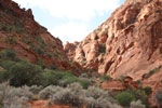 The Red Cliffs Recreation Area offers many hiking trails that lead you through beautiful red rock formations and desert landscapes. The Red Reef trail is a six mile long trail that leads from the Red Cliffs Recreation Area to the Cottonwood Canyon Wilderness Area. If you’re not up to a six mile hike through southern Utah’s red rock desert no problem. The lower portion of the Red Reef trail meanders its way up Water Canyon providing spectacular views and leads to a slot canyon featuring pools of water and red rock gorges; all within a 1/2 mile or so from the parking lot.
University of Utah BLOCK U
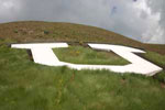 Get up close and personal to the BLOCK U that sits 5300 feet above sea level over looking the University of Utah and surrounding Salt Lake Valley. This landmark was first constructed in 1905 and improved over the years with concrete, lights and erosion control. The BLOCK U stands 100 feet tall and can be seen for miles. The landmark was constructed mostly for athletic events held on the University of Utah campus. When victorious the BLOCK U Flashes and when defeated the lights burn steady. Whether you’re a Ute fan or not come up a see the BLOCK U you will be amazed by the size and construction of this famous landmark.
Grotto Trail - Payson Canyon Utah
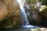 Located about 7 miles up Payson Canyon is the Grotto Trail, commonly known as Grotto Falls. The trail is short, wide, with little elevation gain making it a great trail for all ages. The hike begins from the parking area just off the Mount Nebo Loop Road. It follows a small stream and curves its way through the forest. In a few locations you cross the stream on large timbers put in place by the forest service. This adds excitement to the trail, especially for the kids. Once you reach the end of the trail you are greeted with a beautiful waterfall cascading into a small pool of water, surrounded by steep rock walls.
The Box Canyon Hiking Trail - Maple Canyon Utah
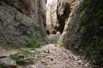 Less than one mile up Maple Canyon is the Box Canyon Hiking trail. There will be a pull out to your right and the trail head will appear to be nothing more then a dry streambed. This trail is unmarked so as you head up the canyon keep a lookout to your right for this pull out. This trail is very popular not only for hikers but rock climbers too, so chances are other vehicles will be parked is this area. As you begin this hike you will immediately understand where the canyon got its name. The rock walls tower hundreds of feet over your head with the widest part of the base being approx.