This article may include affiliate links. If you click a link and make a purchase, Utah Outdoor Activities may receive a small commission at no extra cost to you. We only recommend products or services we personally use. FTC Affiliate Disclosure.
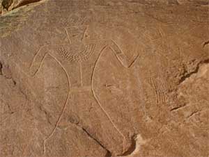
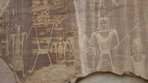
The rock art located up Dry Fork Canyon is world renowned and located along a 200-foot-high "Navajo Formation" sandstone cliff. These petroglyphs are located on the Sadie McConkie Ranch, a private property, but have remained accessible to the public, all they ask is that visitors do not damage the sites, and obey all signs. Nowhere else can you see more petroglyphs in one area that are so easily accessible.
There are trails that take you up close and personal were you can view figures up to 9 feet tall. These figures represent the Fremont culture, which flourished in this area from about 1-1200 A.D. You may spend any were from 1 to 8 hours exploring this area, depending on how far you want to hike and how much you want to see.
The parking lot for the petroglyphs is located 3/4 of mile off the main canyon road and is accessible year round. Dry Fork Canyon also offers beautiful shady picnic areas for relaxation. For those interested in driving or mountain biking, you may take the East Park loop trip by starting at the northern end of Dry Fork Canyon. You may also drive the Red Cloud Loop Scenic Backway recommended for high-clearance vehicles. This scenic backway will take you high up into the Ashley National Forest which offers camping, fishing, hiking and picnicking opportunities.
Directions To Dry Fork Canyon:
From the center of downtown Vernal (Hwy 191 and Main street), head west to 500 West, turn north (right) and head out on the Maeser Hwy (121) to 3500 West.
Turn North (right) and head about 10 miles up the road until you reach a major fork in the road (a sign reads "Red Cloud Loop") and turn right. Cross the bridge and continue on the pavement for another two miles until you reach the shade of the cottonwoods, boxelders, steep canyon walls, and a large stream which is Dry Fork Creek.
Nearby City:
Nearby Lodging:
Vernal Utah Hotels (Affiliate Link)
We hope you enjoyed this information. For more outdoor activities, please connect with us on YouTube, Facebook and Instagram. Help us keep this site up and running by visiting our online store which features outdoor themed gifts, decor and more. Thank you for visiting and for your ongoing support!