This article may include affiliate links. If you click a link and make a purchase, Utah Outdoor Activities may receive a small commission at no extra cost to you. We only recommend products or services we personally use. FTC Affiliate Disclosure.
The Little Hole trail is an exceedingly scenic walk that winds through the bottom of Red Canyon on the north shore of the Green River. The canyon’s brilliant colors so impressed John Wesley Powell on his expedition down the Green River in 1869 that he named it the Flaming Gorge. A century later, in 1964, the Flaming Gorge Dam submerged most of Powell’s spectacular canyon with water, but a small section of it, Red Canyon, still remains below the dam to remind us of how the Flaming Gorge got its name.
In the past thirty years, since the creation of the Flaming Gorge National Recreation Area, the Forest Service has developed Red Canyon as a premier sport fishing area, and you are likely to encounter dozens of fishermen along the Little Hole trail. If you crave solitude this is the wrong hike, but, for me, watching the fly fishermen ply their skill is an added bonus. Few rivers offer a more perfect setting for fishing than the Green, and Red Canyon is kept abundantly stocked with rainbow and brown trout. Trout as large as 22 pounds have been caught here.
This hike can be done in either direction. The west-to-east route described here is best if you are hiking in the afternoon, as the sun will then be at your back. If, however, you are planning a morning hike, you can avoid having the sun in your face by starting at Little Hole rather than the dam.
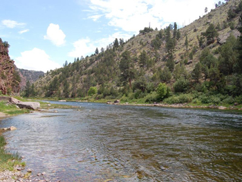
From the boat ramp parking lot below Flaming Gorge Dam a sign will direct you to a small footpath, about 0.2 miles long, that descends to the boat ramp. You will find the Little Hole trailhead just beyond the boat ramp on the downstream side. The scenery starts almost immediately, as the red shale and sandstone cliffs of the Mancos Formation soar on either side of the river to a height of about 600 feet. For the next four miles the elevation of the canyon rim steadily increases, finally reaching a height of 1000 feet above the water.
A series of small rapids breaks the monotony of the clear water, with whimsical names like Rollercoaster, Skinny Dip, and Mother-in-Law. The rapids are usually not particularly hazardous, but it is fun to watch the boaters negotiate them. After the first two miles there is a noticeable decline in the number of fishermen, but their numbers begin to pick up again along the last two miles of the trail. Finally, after six miles, the river emerges from Red Canyon and widens somewhat as it approaches Little Hole.
More Information:
Flaming Gorge National Recreation Area
P.O. Box 279
Manila Utah, 84046
Phone: 435-784-3445
Camping in the Ashley National Forest
Nearby City:
Nearby Lodging (Affiliate link)
Other Articles of Interest:
Visiting the Flaming Gorge Dam
We hope you enjoyed this information. For more outdoor activities, please connect with us on YouTube, Facebook and Instagram. Help us keep this site up and running by visiting our online store which features outdoor themed gifts, decor and more. Thank you for visiting and for your ongoing support!