This article may include affiliate links. If you click a link and make a purchase, Utah Outdoor Activities may receive a small commission at no extra cost to you. We only recommend products or services we personally use. FTC Affiliate Disclosure.
Said to have been carved by an ancient underground river the West Desert Sinkhole was discovered in 1927 by Joseph Nielson. Nielson was driving some mules on a dark night back to his camp when he strayed into the area by mistake. Nielson's horse stopped and refused to take another step. Nielson got off his horse and started walking forward when suddenly, the ground below his feet gave way tumbling into the unseen sinkhole. In desperation, he held onto the reins and his horse quickly backed up, pulling him away from the yet unseen danger.
Neilson remounted his horse leaving the reins limp, placing his trust in the horse. His horse reportedly backed up for another 50 feet before he veered away at a 90 degree angle and trotted off to safety. The next day, Neilson retraced his steps.
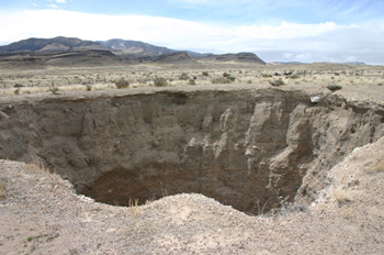
As he approached the sinkhole, his horse refused to go anywhere near it. As Nielson continued, what he saw made his knees so weak he had to sit down. There before him was a sinkhole that he estimated was about 90 feet deep and 70 feet across.
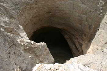
 Early visitors to the hole reported the sinkhole opened at the bottom into a tunnel carved through sedimentary silt, left by an ancient river or lake. They said they could walk back into the ancient riverbed tunnel for quite some distance.
On the east side, so much dirt and rocks have fallen in the rim is only about 55 feet above the floor, whereas on the west side of the sinkhole the rim is almost 100 feet away from the floor. The bottom of the sinkhole is much larger than at the rim, making it very hard to climb out by using rope. The BLM has built a fence around the sinkhole to keep cattle and unsuspecting people from straying into it. Do not attempt to climb down into the hole! The edges around the hole are undercut making it very dangerous to get too close. The rock is very loose, making it easy to lose your footing and send the onlooker to the bottom with gravel and rocks raining down upon them. Just use caution when visiting and I guarantee you too will lose your breath when you approach this hole just as Joseph Nielson did.
There a two ways you can visit the sink hole:
Drive on highway 6-50 to the road that goes to the U-Dig Fossil site. Drive north on the gravel road for 6.8 miles to the Y intersection next to Long Ridge Reservoir (usually dry). Take the left fork, driving for 1.6 miles to a T intersection. Turn left (south) and drive 3.3 miles to a road that leads west. Drive west for 3.4 miles to a Y intersection. Take the right fork of the Y, heading northwest for one mile. Turn right, drive north for .6 mile. Turn right again, drive southwest for about a half mile to a parking area next to the fence that surrounds the sinkhole.
Directions via the Amasa ATV Trail
From Delta travel approx 44.2 miles on Highway 6-50 to an dirt road marked with an old sign saying "Scenic Byway Loop Rd 6-50". Travel North on this road for approx 4.3 miles to the Miller Canyon sign. You can travel up Miller Canyon to the first ATV trail staging area and just follow the map to the sink hole. To get to the next ATV trail staging which will put within approx 2-3 miles from the sinkhole. Travel from Miller Canyon approx 10.9 miles to the Marjum Pass turn off. Travel west on this road until you reach a Y in the road approx 4 miles up the road. Take the left fork marked Amasa Valley. Travel approx 5.1 miles to the Amasa ATV Trail staging area. From the staging proceed down trail #1 until it splits to trail #5. Take trail #5 to the sinkhole.
Nearby Lodging (Affiliate Link):
Other Articles of Interest:
Trilobite Collecting At U-DIG FOSSILS
Topaz Camp - Japanese Relocation Camp
Miller Canyon Utah's West Desert
We hope you enjoyed this information. For more outdoor activities, please connect with us on YouTube, Facebook and Instagram. Help us keep this site up and running by visiting our online store which features outdoor themed gifts, decor and more. Thank you for visiting and for your ongoing support!