Previous Page
The Huge Cave - Maple Canyon Utah
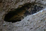 The trailhead for the Huge Cave is located approx 1.8 miles up Maple Canyon; there are two areas to park at the end of the Maple Canyon Campground. The trailhead is located on the left hand side of the road. This trail is not marked Huge Cave but has a sign listing the Right Fork, Middle Fork and View Point trails. The start of the trail is relatively flat with trails leading off; these trails lead you to the several established climbing routes that are available up this canyon. After you pass these arms you will reach a fork, head to the left and continue up the trail.
Waterfall Canyon Hiking Trail
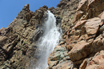 Ranked one of the most popular trails in Ogden, the Waterfall Canyon trail begins at the top of 29th St. The trail head is called the 29th street trail head and is the access point to a series of marked trails including the Bonneville Shoreline trail. From the parking lot, the Waterfall Canyon trail heads east and begins to climb its way into the foothills. A portion of this trail leads through private property. In the past this section has been closed by the landowner because of vandalism and trash left by the hikers. Please when making your way through the private section stay on the trail, don’t leave any trash, and respect the landowner's property.
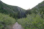
The Sound Of Silence Hiking Trail - Dinosaur National Monument
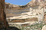
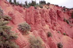
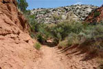 The Sound Of Silence Hiking Trail is the second point of interest on the Tilted Rocks Auto Tour. This trail is a moderated to difficult 3-mile route that will take you through arid landscapes, towering stone walls, and down dark red paths. The beginning of this hike takes you through a flat sage brush valley and makes its way into a tree and brush covered wash with views of towering stone walls. Do remember you are hiking in a wash so watch the skies and listen for sounds of possible water heading your way. As you continue down the wash the trees and brush offer relief from the hot summer sun.
Wall Lake Solo Hike and the Hydroblu Test
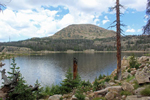 In this outdoor activity, I take a hike to Wall Lake in the Uinta Mountains. The trail head begins in the Crystal Lake parking lot, which is one of many trails in this area. The hike to Wall Lake is 2.5 miles round trip with little elevation gain. This makes it a family friendly hike that can be enjoyed by people of all ages. This is a very popular trail, so if you are looking for seclusion, this hike may not be for you. The parking area for Wall Lake and many other trails is limited. When I arrived early Friday morning it was difficult to find a parking spot. However, even though the parking lot was full doesn’t mean everyone is hiking to Wall Lake. The trail head to Long Lake and many other higher elevation lakes begin in this same parking area.
The Hog Canyon Hiking Trail - Dinosaur National Monument
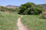 Hog Canyon is one of the box canyons that Josie Morris used as a natural corral by fencing off the narrow end of the canyon. This trail begins to the east of the Josie Morris Cabin, Dinosaur National Monument. This trail will lead you past Josie's chicken coop and a pond that stored water from her natural spring. The trail is flat and provides views of the land that surrounds the cabin. Once you begin your hike into Hog Canyon you will find yourself surrounded by tall grasses and wild flowers with views of towering walls. As you continue up this trail the steep canyon walls will begin to narrow and you will end up in a heavily forested area that you can sit and relax, while taking in the beauty.
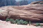
The Box Canyon Hiking Trail - Dinosaur National Monument
 The trail head for this hike begins in the parking area of the Josie Morris Cabin, Dinosaur National Monument. This trail will be a relief from the hot summer sun. The trail itself is flat and will even offer shade in the mid-day. Josie Morris used this canyon as a natural corral where she raised her cattle. She simply fenced off the narrow end of the canyon and let the canyon walls confine her stock. As you continue up this trail the steep canyon walls will begin to box you in and eventfully you can go no further.
Avenue Twin Peaks Hiking Trail
 Avenue Twin Peaks over look the Avenues and the University of Utah. The trail begins at Perrys Hollow Rd 1250 East 640 North in Salt Lake City. You begin by starting up a jeep track that winds around a ridge to your first overlook of the city. You can see Mt Vancott clearly from here, as well as all of the University of Utah, and the Medical Center. The trail continues up another hill that puts you directly at the base of the Twin Peaks. Continue to follow the jeep track along the west side of the twins and this will lead you to a small saddle, were you may climb to the top of the first Twin.
Bennie Creek Hiking Trail
 The Bennie Creek trail is located 6.6 miles up Payson Canyon. This is a great day hike for the whole family. The trail is 3 miles to Loafer Mountain summit trail. At this point you could continue another 5 miles to the summit or take the other fork another 1 mile which would put you back on the Mount Nebo Scenic Highway. We turned around at this point and headed back down the mountain. The trail offers some fairly steep sections, flat meadows, and a few switch backs. The bottom started out in the junipers and as we climbed higher we found ourselves in beautiful groves of aspen and pine trees.
Devils Kitchen
 The Devils Kitchen hiking trail is an outstanding geological formation located up Payson Canyon. This short hike less than 1/4 mile long takes you through pines and quaking aspens and offers a beautiful view of a red rock formation. While standing on the platform over looking the formation its almost as if you were over looking a canyon in southern Utah. The parking area is 27.7 miles from the mouth of Payson Canyon. The trail is paved and wheelchair accessible. The trail head offers pit toilets and picnic areas.
Hiking Snow Canyon
 Snow Canyon offers beautiful day hike's through red and white Navajo sandstone, capped by black lava rock. Before hiking in a desert environment like Snow Canyon make sure you are prepared. Carry at least one liter of water per person. Do not hike alone. Avoid hiking when temperatures are extreme. Otherwise keep your hike short, wear a hat and sunscreen, and bring water. Climbing the rocks in Snow Canyon is dangerous. They should be attempted only by experienced climbers with the proper equipment. The distances in the trails listed below are round trip. The trails are in order from the first to the last if you enter the park from Ivins St George.
Hiking Kings Peak- The Highest Peak In Utah
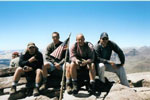 Kings Peak the highest peak in Utah standing at 13,528 feet is one of the more popular hikes in the state of Utah. 5,000 plus visitors hike to the summit every year. With there being several different routes to get to the summit, the easiest route that my friends and I decided to take was the Henrys Fork Trail. To get to the Henry Fork trail you must go into Mountain View, WY. Then take State Route 410 south towards Robertson. When 410 makes a hard left (west) in about six miles, stay due south towards Bridger Lake Guard Station. In about 12 miles, turn east on Forest Service Road 077 towards Henrys Fork.
Little Hole National Recreation Trail
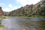 The Little Hole trail is an exceedingly scenic walk that winds through the bottom of Red Canyon on the north shore of the Green River. The canyon’s brilliant colors so impressed John Wesley Powell on his expedition down the Green River in 1869 that he named it the Flaming Gorge. A century later, in 1964, the Flaming Gorge Dam submerged most of Powell’s spectacular canyon with water, but a small section of it, Red Canyon, still remains below the dam to remind us of how the Flaming Gorge got its name. In the past thirty years, since the creation of the Flaming Gorge National Recreation Area, the Forest Service has developed Red Canyon as a premier sport fishing area, and you are likely to encounter dozens of fishermen along the Little Hole trail.
Neff's Canyon Hiking Trail
 Neff’s Canyon lies directly south of Mill Creek Canyon. It is the spur canyon that runs at the base of Mt Olympus. If you hike to Thayne Canyon pass, it puts you on the Wildcat Ridge in between Mt Raymond and Mt Olympus. This hike starts at the trail head in White Park. There is a small parking lot and the trail head begins on the left. It climbs a short jeep track, until you reach the first landmark which is a water tower and a small service shack with a chain link fence around them. This is a great place to get some of your first elevation shots with a camera, as well as to take in some of the first rock formations that are on the ridge above.
Rocky Mouth Falls - Sandy Utah
 The Rocky Mouth Trail is a great short hike to get out and cool off, on a hot summer day. The Trail head is located at 11300 south Wasatch Blvd. You park in the Wasatch Trail Head Lot, then ascend a railroad tie staircase to the subdivision road. The road curves to the left and on the right, in-between 2 houses, is the trail. The initial hill is quite steep, but manageable. It levels off to another incline, then follows a foot path to the left, around some snarled Cottonwood trees, past a sealed mine shaft, and another rock formation that has a small cave, but not large enough to enter. The up another small incline and the falls will be in full view. This hike is so short you could even pack in a light camping chair, so you would have a nice place to sit and enjoy the view.