Previous Page - Next Page
Bear Lake Raspberry Days
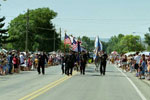 Bear Lake's delicious harvest of Raspberries occurs in early August. The celebration of this harvest brings rodeos, parades, fireworks and a craft fair. This annual event is well known as Bear Lake Raspberry Days. This event attracts people from all over the world not only for the delicious raspberries and the festivities but for the beautiful location it is held in. The Raspberry Days parade is held on Thursday and people line the main street of Garden City early to get a spot. The parade is filled with floats, marching bands, antique cars, drill teams and more. The participants in the parade usually have bags and bags of candy and beads, which is thrown into the crowds as they make there way down the parade route, so be sure your kids are prepared with a large bag to collect all the goods.
The Beaches Of Bear Lake
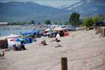 Bear Lake, well known for its cool Caribbean-blue waters but what about the ocean like beaches that surround the lake. Bear Lake has always had nice sandy beaches but the drought over the last few years has exposed even more of this fine ocean like sand. There are several public access routes that will allow you to drive your vehicle right onto the beach. Just a word of caution the sand in some places is very deep. Stay on the well traveled routes until you near the packed sand by the water. I have witnessed several vehicles buried up to there doors in sand, this would be one hefty tow truck bill for anyone.
Milky Falls
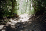
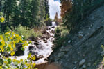 In early June my family spent a weekend in the Manti La-Sal National Forest. We spent the weekend riding the ATV trails the forest has to offer. We were heading up Manti Canyon where we saw the sign above. You could hear the water cascading down the falls, but not really being able to see through the trees, we decided to go see what Milky Falls was all about. When the falls came into to full view, we were amazed at its simple beauty. This time of year the falls were flowing very heavy, due to the snow melt. The run off made the falls much more impressive.
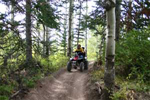
Bear Lake ATV Trails - Shoshone ATV Trail System
 The Bear Lake KOA is a perfect location to begin a great day of exploring the Shoshone ATV trail system. Directly behind the park is a trail head that will lead to hundreds of miles of ATV trails. From the KOA the trail follows the lower portion of the mountain behind Garden City, Utah. You will travel by an operational gravel pit then turn right and head up the mountain until you come to a "Y" in the trail. Travel Southwest, and this portion will take you to the Bear Lake Overlook up Logan canyon. The trail will lead you through thick groves of Pines, Aspens, Wildflowers, and of course provide spectacular views of Bear Lake.
Mantua ATV Trails - Willard Peak Road
 The Willard Peak Road is located south of Mantua Utah. This area is very popular for camping, mountain biking and OHV use. The road is approx 12 miles long with ATV trails leading off in every direction. A great place to stage and enjoy the many riding opportunities this canyon offers is at Doc's Flat, which is located 1 1/2 miles up the canyon. From the Doc's Flat area you can travel up Willard Peak Road to the top which dead-ends at Inspiration Point. On are visit the snow stopped us from going to the top, but we heard the views of the Wasatch Mountains, Cache Valley and the Great Salt Lake are spectacular.
Amasa ATV Trail
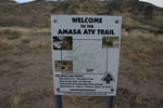 The Amasa ATV trail is located approx 51 miles west of Delta Utah. This trail offers riders 33 miles of desert and mountainous terrain ranging from easy to most difficult. Old mines and mining relics can viewed along its route. The trail borders the Notch Peak Wilderness Study Area with Notch Peak in plain view. Notch Peak is a 3,000 foot sheer cliff made of limestone and is hailed by many as the second tallest cliff face in America, second only to El Capitan in Yosemite National Park. The peak towers 9,725 feet above the desert valley which has an elevation of about 5,000 ft.
Clay Canyon | Clay Canyon OHV Area
 The turn off to Clay Canyon is located 1.5 miles from the town of Fairfield Utah. This Canyon is well known as being the location mined for Variscite. This yellow and green mineral were mined for the jewelry trade, which continued up until about World War I. Now days the mineral is collected by rock hound enthusiasts for personal use only. If you plan on collecting this mineral, you had better do some homework before hand. It takes a very trained eye to spot the rock the mineral is located in and in most cases the rock will have to be cut open to expose the Variscite.
The Maple Canyon / Log Canyon ATV Trail Loop - Fountain Green Utah
 This ATV trail loop is approx 34 miles round trip that will take you through Maple Canyon; rated one of the top rock climbing locations in the world; and back down Log Canyon. You will be amazed by the completely different diversity of the two canyons. Maple Canyon has sheer cliff walls, where Log Canyon has thick groves of Pines, Aspens and rock formations. The road leading to Maple Canyon is paved until you reach the mouth of the canyon where the road will immediately turn to dirt. Less then one mile up the canyon you will come to a hiking trail called Box Canyon.
Lake Canyon Campground And ATV Trail System
 Located 18 miles up Fairview Canyon is the Lake Canyon Campground. The campground itself is situated on top of the Wasatch Plateau surrounded by Aspens, Pines, Sage Brush valleys and several reservoirs. What makes this campground unique and very enjoyable to visit is that ATV's are allowed and there are numerous ATV trails, accessible from nearly every campsite. The ATV trails are part of the Lake Canyon ATV trail system and are clearly marked. This trail system offers 9.5 miles of trails that are rated "easy" meaning grades are not to steep and the tread surface is relatively smooth.
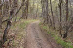
ATV Trail # 255 - Logan Canyon
 This trail is located approx 6.5 miles up the Hardware Ranch Road in Logan Canyon. The trail starts off as a basic road and makes a short loop back to the Hardware Ranch Road, with only one hill that may cause distress. The trail begins as a slow easy low grade climb through sparsely scattered pines. As you summit your first hill there is a great look out perch that you may walk out onto and get a beautiful panoramic view of Logan Canyon. Not to long after the look out point you will come to the hill that I mentioned earlier, I was able to maneuver it on a two wheel drive so for anyone who has spent any time on a bike it really shouldn’t cause to much stress, however if you have younger riders they may have a different opinion.
ATV Trail # 175 | Logan Canyon
 This trail head is approx 5.9 miles up the Hardware Ranch Road in Logan Canyon. The trail is mostly surrounded by Quaken Aspen, which swoop over the trail and provide some refreshing shade. This trail is only about 3 miles long, and dead ends at a couple of cattle watering holes. The kids will really enjoy the little ponds because you can see the salamanders swimming all around. However there were bees everywhere especially the closer you were to the ponds. Once away from the ponds they seemed to leave you alone. There were only two or three locations on this trail were it got a little rough, pretty much just large rocks, and fallen trees to bounce over. There were no steep grades, or severely washed out ruts to contend with so it made for an easy and short trail. Oh and keep your eyes open for cow’s on the trail, they are probably the largest obstacles you will encounter.
Hodges Canyon ATV Trail # 028 | Logan Canyon
 Located 1.5 miles down the Hardware Ranch Road in Logan Canyon you will come to a very large staging area. This is the staging area for the Hodges Canyon ATV trail, but it's also a good place to stage and access several other ATV trails on the north end of the Hardware Ranch Road. This trail starts off in a large sage brush valley with not much in the way of trees. After you crest the first little hill you began to descend into a canyon. The trail runs down into a narrow valley and along a small stream that you will have to cross several times. There were a few short hills with large rocks, and fallen trees to maneuver around and over, however this is not a difficult trail.
Little Bear ATV Trail | Logan Canyon
 The Little Bear ATV Trail is located up Logan Canyon just off the Hardware Ranch Road. The trail head is clearly marked with a small wood sign. This trail is just one of the many ATV trails in this area, plus the Hardware Ranch Road is open to ATV travel. We heard that this trail was very rough and if you are not an experienced rider that you may want to choose a different trail. As we pulled up to the trail head someone has written on the sign "very difficult towards the bottom". After seeing that we were convinced that this trail may have some difficult spots.
Casto Canyon ATV Trail
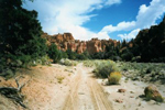 Beginning at the Casto Canyon trailhead the trail takes you into a wonderful world of red hoodoos, sandstone cliffs of white, pink and even green colors. The spectacular red rock is evident along most of the Casto canyon ride until you reach the forested areas of ponderosa pines where the colors changes with every turn of the trail. This trail includes several passages through the usually dry riverbed but local heavy thunderstorms can and will change that quickly. The trail goes upwards easterly for approx 5.5 miles where it connects to the Sanford Road and the trail continues northeast approx., 1.9 miles and is referred to as the Barney Cove Trail.
Bullion Canyon and The Miners Park Recreation Trail
 The Bullion Canyon trail head can be accessed from Marysvale at the heart of the Paiute ATV Trail in Piute County. The Bullion Canyon Trail System begins at the bridge over Pine Creek on the Bullion Canyon Road (FR-126) just below Miners Park. From the bridge (7,840 ft) the Bullion Canyon Trail (074) rises over 2,800 ft in 5.5 miles. This trail offers ATV enthusiasts not only a ride through beautiful stands of aspen and pines, but also a historical drive through the Old Bullion City. Remains of the old town, established in 1868 include old cabins, buildings, mines and the old mill.